21 Amazing Waterfalls near Winter, Wisconsin
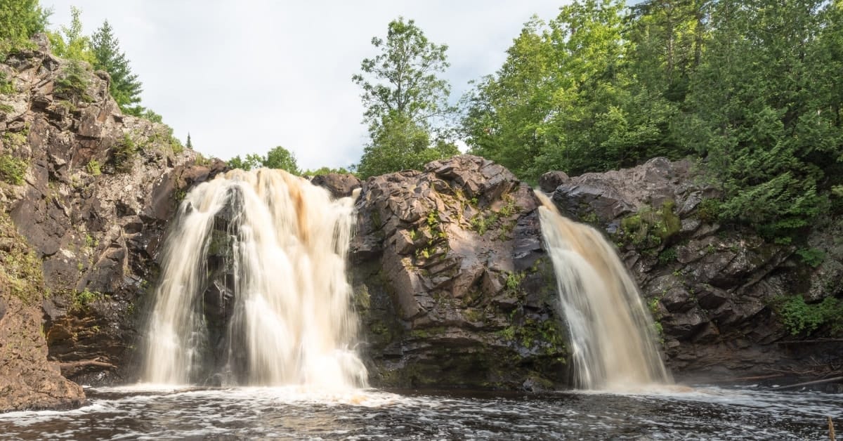
Some of the most spectacular waterfalls in Wisconsin are located along the south shore of Lake Superior in Ashland, Bayfield, Douglas and Iron counties. While this does require what would be considered a "Day Trip", you're not too far from some of the best waterfalls in the state of Wisconsin.
State and county parks usually provide public access, although private property borders some of the falls. Please stay on established trails and take caution at water's edge. Some locations are remote and require hiking across difficult terrain.
21 Waterfalls Near Hayward, Wisconsin
We have identified a total of 21 waterfalls you can visit during your next vacation to Winter, Wisconsin.
1. Copper Falls State Park
Just two miles northeast of Mellen Wisconsin on Hwy 169. A park permit is required to enter the property, but you can enjoy camping, boating, swimming, fishing, hiking nature trails and even stopping at the concessions stand within the park. Copper Falls State Park is open year round.
2. Morgan Falls
Morgan Falls on Morgan Creek is located just 9 miles south of Ashland on Hwy 112. This little hidden treasure is located down a dirt road. The dirt road is Ashland-Bayfield Rd, and that follows about 4 miles into the deep Chequamegon-Nicolet National Forest. The trail-head is a beautifully renovated parking lot with parking spaces, park benches, and has great signage to help you explore the area with ease.
BONUS: An added bonus with Morgan Falls is St. Peter's Dome. St. Peter's Dome is just 1.8 miles through rugged terrain, but nicely marked trails leading you to the top of "Old Baldy." The trek to the top of St. Peter's Dome is well worth the effort; the panoramic view of the Chequamegon Bay of Lake Superior, and the Apostle Islands, is an unforgettable experience.
3. Houghton Falls Nature Preserve
Houghton Falls Nature Preserve is located 3.5 miles north of Washburn, Wisconsin on Houghton Falls Road. The .75 mile trail traverses some beautiful natural features before ending at the edge of Lake Superior - far above the water. The waterfall flow is seasonal, but the trek to the edge of Lake Superior is definitely a visual that you're not likely to admire without being physical in presence.
4. Lost Creek Falls
Lost Creek is just 3 mile south of Cornucopia, Wisconsin on Hwy C. Lost Creek Falls is located on Trail Drive. The trail is well-marked and comes with a boardwalk and gravel which lead you to Lost Creek Falls. This short trek is perfect for those just wishing to see some of the Northwoods beauty.
5. Orienta Falls
Orienta Falls is located on the Iron River, just 5 miles east of Port Wing, Wisconsin. This is another quick trek down a undeveloped trail that leads to a beautiful area where you can view the falls.
6. Siskiwit Falls
Siskiwit Falls are located just .25 miles from Cornucopia, Wisconsin off of Hwy C on Siskiwit Falls Road. There are two new parking areas with off-road parking on both sides of the river. The southern-most falls, upstream from the bridge, are accessible by a short path on the southern side of Siskiwit Falls Road.
7. Twin Falls
Twin Falls is located just outside of Port Wing, Wisconsin on the south side of Hwy 13. There is a path that leads to an observation deck looking down on Larson Creek flowing over the falls and the cavern beneath you. This is another with trek.
8. Pattison State Park
Pattison State Park is located on State Hwy 35, 13 miles south of Superior, Wisconsin. Pattison State Park comes complete with spectacular scenic overlooks, camping, hiking, swimming, boating, and fishing. Pattison State Park is open year round and has two major water falls for you to visit.
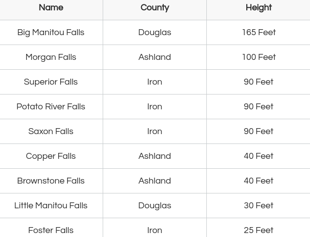
- Big Manitou Falls
- Little Manitou Falls
9. Amnicon Falls State Park
Amnicon Falls State Park is located on Hwy 2, just 10 miles east of Superior, Wisconsin. Amnicon Falls State Park has well groomed and well marked trails, multiple bridges overlooking the falls. There are a total of 7 waterfalls within this state park to see.
10. Foster Falls
Foster Falls is located on the Potato River just 5 miles north of Upson, Wisconsin. Foster falls provides a short trek to see 25 ft waterfall that has a 5 foot wide crest.
11. Interstate Falls
Interstate Falls is located on the Montreal River in Hurley, Wisconsin. The trail is just .3 miles long before you get to the Interstate Falls overlook.
12. Kimball Park Falls
On the west branch of the Montreal River, just 3 miles east of Hurley, Wisconsin. The falls take you across a one-lane bridge into the area to see Kimball Park Falls.
13. Lake of the Falls
On the Turtle River, just 5 miles west of Mercer, Wisconsin. Lake of the Falls has a nice picnic area for resting and has spots for cooking out and spending time with the family while viewing the falls area.
14. Potato River Falls
On the Potato River, the Potato River Falls provide a 90 foot drop from the Potato River. Potato River Falls has rustic camping sites, a town park, and picnic areas.
15. Rouse Falls
Rouse Falls is one of the more remote locations that provide a scenic waterfall scene. Just 2.5 miles outside of Upson, Wisconsin Rouse Falls has a .75 mile on a rustic trail to get to the Rouse Falls area.
16. Saxon Falls
On the Montreal River, just 9 miles west of Hurley, Wisconsin you will find Saxon Falls.
17. Shay's Dam Falls
On the Turtle River, just east of Mercer, Wisconsin on County Hwy J, turn north on Beaver Lodge Circle, go 3.6 miles to Fisher Lake Road, turn east and go 1.2 miles. Watch for Shay's Damn signs, and you'll reach your destination.
18. Spring Camp Falls
On the Montreal River in a very remote location, south from Hurley, Wisconsin on State Hwy 51, 4.5 miles. Turn west on County Hwy C. In about 1.5 miles the road turns sharply north - don't take that. Continue forward on the gravel road for about a mile, turn south, following East Branch Road another 3 miles. At the fork, continue right about a mile. Follow the rustic path signs to see Spring Camp Falls.
19. Superior Falls
On the Montreal River. Take US Hwy 2 west from Hurley, Wisconsin, 11 miles, turn north on State Hwy 122. Travel approximately 4.2 miles, crossing the Wisconsin-Michigan border. Contineu .5 miles , turn left on a gravel toad to the Wisconsin Electric power station and you'll land at the Superior Falls.
20. Upson Falls
On the Potato River. From State Hwy 77, turn north at the Upson Town Park sign, then left at the end of the street. After crossing the river, turn left into Upson Town Park to land at Upson Falls.
21. Wren Falls
Wren Falls is located on Tyler Forks River. In a very remote location, go 5.5 miles south of US Hwy 2 on State Hwy 169. Turn east on Vogues Road (gravel), and go 3.5 miles to a hairpin turn. Take the center road one mile to a for in the road. Hike up the hill to see Wren Falls.
Tallest Waterfalls in Wisconsin
